Contact
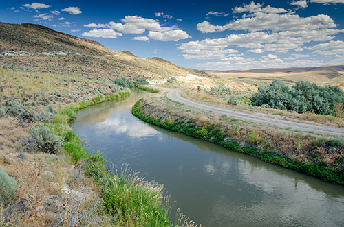
 The Harper Southside Canal near Harper. (Oregon State Archives Scenic Images collection)
County Seat: 251 B St. W., Vale 97918
Phone: 541-473-5151 (General); 541-473-5171 (Court Administrator)
About
Established: Feb. 17, 1887
Elev. at Vale: 2,243'
Area: 9,926 sq. mi.
Average Temp.: January 28.7° July 75.6°
Assessed Value: $2,724,369,750
Real Market Value: $4,493,107,980
(includes the value of non-taxed properties)
Annual Precipitation: 9.64"
Economy: Agriculture, livestock, food processing and recreation
Related Resources

Historical Records Inventory
Malheur County Scenic Images
"County QuickFacts" (population and economic data from U.S. Census Bureau)
County Seat Map (from Google Maps)
County Map (from ODOT)
Incorporated Cities
Points of Interest
Oregon Trail, Keeney Pass, Owyhee Lake, Succor Creek State Park, Leslie Gulch Canyon, Jordan Craters, grave of trapper John Baptiste Charbonneau, Nyssa Agricultural Museum, Vale Oregon Trail Murals, Jordan Valley Basque Pelota Court, Four Rivers Cultural Center
History and General Information
Malheur County was created in 1887 from Baker County. The county derives its name from the “Riviere au Malheur” (Unfortunate River), which was later changed to “Malheur River,” so named by French Canadian trappers whose property and furs were taken from their river encampment.
Malheur County is Oregon’s second-largest county by land mass. The landscape provides for a wide variety of excellent recreation such as hunting, fishing, hiking, rock climbing, rock hounding, boating and water skiing. The county is 94% rangeland. Basques (primarily shepherds) settled in Jordan Valley in the 1890s. Irrigated fields in the county’s northeast corner, known as Western Treasure Valley, are the center of intensive and diversified farming.
County Officials
County Court: Judge Dan Joyce (2027); Ron Jacobs (2029), Jim Mendiola (2027); Dist. Atty. David M. Goldthorpe (2027); Assess. G. Chris Russell (2029); Clerk Gayle Trotter (2027); Justice of the Peace Margaret (Margie) Mahony (2031); Sheriff Travis Johnson (2029); Surv. Tom Edwards; Treas. Jennifer Forsyth (2027); Co. Admin. and Chief Information Officer Lorinda DuBois