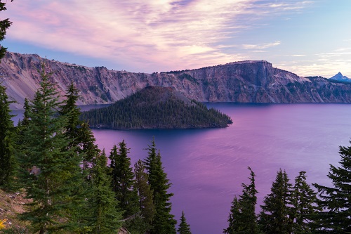
 Traditional stories of Native peoples told of the eruption of Mount Mazama, which created Crater Lake. (Oregon Scenic Images collection)
 Oregonians have a long and complex relationship with the extraordinary environments and natural worlds in which they live. Take predators like coyotes and wolves, for example. In the oral traditions of many Oregon Native peoples, Coyote is a clever trickster whose adventures teach moral lessons that deserve respect and understanding. Wolves commanded respect from the British, French Canadians, and Americans living in Oregon in the mid-19th century, too. Their fear of wolves brought them together along the banks of the Willamette River for the “Wolf Meetings” in 1843, to discuss how to eliminate predators (additionally, they created Oregon’s first government). That anxiety faded in the following decades as Oregonians developed the ability to control wolves, which disappeared from the state by the 1940s. But when wolves returned to Oregon at the end of the 20th century, they once again warranted the respect of Oregonians: many rural residents regarded the animals as a continued dangerous threat to life and property, while city-dwellers often saw them as noble, wild creatures deserving protection.
These wolf stories provide a glimpse into many aspects of Oregon’s history: the long presence of humans, the variety of communities that have made this place home, the combination of pragmatism and ideology that characterizes Oregon politics, the tension between the state’s urban and rural populations and the spirit of cooperation and compromise that often brings Oregonians together. Through it all, a larger theme emerges: the changing relationship between Oregonians and nature. For millennia, Oregon’s landscape demanded respect and adaptation from the people who lived here. That changed in the late 19th century as Oregonians developed tools and methods to manipulate and to try to master their environments. Over time, many Oregonians came to question the destructive effects of such manipulation and instead developed an interest in the aesthetic, the recreational and even the inherent value of Oregon’s landscape. Understanding Oregon’s history requires understanding how Oregonians have related to their environments — and to each other.
Geology and Archaeology
Modern geology and archaeology hold that humans arrived in Oregon at least 14,000 years ago, after a centuries-long migration from Asia via the Bering Strait land bridge and sea-borne routes along the coast. But there are other origin stories, too. Oral traditions from the Klamath and Modoc Native peoples, for instance, speak of beings who dug tunnels under the earth, created the marshes and rivers, made the people, and caused the eruption of Mount Mazama and the creation of Crater Lake. The stories told by science and tradition both emphasize the importance of environmental change at a variety of scales: geological shifts producing the Cascade Mountains, the Missoula floods that raged through the Columbia Basin between 13,000 and 15,000 years ago, and volcanic eruptions like that of Mount Mazama around 7,000 years ago. Such forces and transformations produced evolving ecosystems that dozens of American Indian groups both adapted to and changed. To make sense of this diversity, historians and anthropologists often refer to three (occasionally four) culture areas in Oregon: the Great Basin; the Columbia Plateau; the Northwest Coast which also includes the “western interior” of the Willamette Valley; and Southern Oregon.
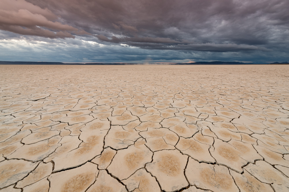 Northern Paiute peoples thrived in a range of Great Basin environments such as the Alvord Desert. (Oregon Scenic Images collection)
 To an outsider, the Great Basin might seem desolate and even barren. But the Northern Paiute peoples and their ancestors created life and opportunity in this home. Encompassing the southeast quarter of Oregon and stretching far beyond the state, the Great Basin includes Steens Mountain, the Alvord Desert, and Harney and Malheur lakes. Those who knew the landscape, manipulated and made sense of these environments not just to survive, but to thrive. That knowledge started with a deep understanding of the location and development of food and other resource production in different places at different times of the year. Northern Paiute peoples made “seasonal rounds” throughout the diverse landscapes of the Great Basin, migrating to places where they knew they would find resources. In the spring, women and children dug up and dried tsuga (biscuitroot), which they made into loaves; men speared and trapped salmon at the headwaters of the Malheur River. Summertime saw the Northern Paiute peoples travelling widely to the north and south in pursuit of deer, elk, groundhogs, and other game, as well as a variety of plants, such as huckleberries and chokecherries. The work continued into the fall, when the Wada’Tika band of Northern Paiutes along the shores of Malheur Lake harvested waada (seepweed), extracting the plant’s nutritious seeds that were stored for the winter. As the days turned shorter and colder, the Northern Paiute peoples gathered at their winter encampments near lakes, living in homes they made of willow branches and tule plants. Along the eastern side of the Cascade mountains in southern Oregon, the Klamath peoples of the Klamath Basin cultivated the additional resources of that area, such as different kinds of fish and waterfowl. Through their knowledge, expertise and the labor represented in their seasonal rounds and the homes they made, these peoples—including today’s Burns Paiute Tribe, the Paiutes of the Confederated Tribes of Warm Springs, and the Yahooskin band of Paiutes of the Klamath—sustained complex and enriching lives in the Great Basin environment.
North of the Great Basin lies the Columbia Plateau, a region defined by the Columbia River’s drainage system east of the Cascade Mountains into northeastern Oregon and beyond to Washington, Idaho, Montana, and British Columbia. The Nimiipuu (Nez Perce), Umatilla, Cayuse, and other peoples of the Plateau developed sophisticated seasonal rounds that ranged throughout the region’s different ecological zones, each providing a variety of foods and other resources. Plateau peoples spent their winters in villages along the upper Columbia River and its tributaries, living in longhouses made of tule mats and consuming carefully preserved food. They crafted baskets, digging implements, fishing spears and nets, weapons and other kinds of technologies. Those tools were put to good use in the spring, first with the gathering of qém’es (camas) and other plants, and then with the expert harvesting of spring nacó’x̣ (salmon). Fishing continued into the summer with steelhead and sockeye salmon runs, along with harvests of cemíitx (huckleberries), mi'ttip (elderberry), and other fruits. The fall meant more plant harvests, supplemented by the hunting of mule deer and the taking of fall nacó’x̣, which was carefully dried and processed into nutritious and long-lasting pemmican.
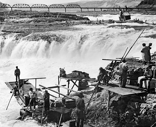
Native Americans fish at Celilo Falls circa 1957. Celilo Falls was a fishing and trading hub for thousands of years. (Image courtesy Oregon Historical Society)
Native Americans fish at Celilo Falls circa 1957. Celilo Falls was a fishing and trading hub for thousands of years. (Image courtesy Oregon Historical Society) These foods also served as valuable trade goods, contributing to a vast network of exchange that connected the Plateau people to other Native peoples throughout and beyond the Columbia River watershed. Wyam (Celilo Falls) on the Columbia River was the largest trading site in what would become Oregon. There, where the river’s power and its huge salmon runs squeezed through narrow passages, Native peoples built communities—including Celilo Village, the oldest continuously-occupied site in Oregon—and cultures that merged traditions from the lower and upper Columbia. Wyam drew people not just for the harvesting of salmon, which became disoriented in the rapids, but also for the trade of an astonishing variety of goods from far-flung locales: whale oil and shells from the west, bison meat and robes from the east, obsidian and weapons from the south, skins and baskets from the north and more. The diversity of goods available at Wyam and at other trading sites indicates the depth and breadth of the material abundance, societies and cultures created by Native peoples.
Some of those who gathered at Wyam came from the Northwest Coast, a cultural region stretching from Alaska to California and defined by mild climate, dense forests and wetness from rain, fog and rivers. In Oregon, Coastal Indian groups included the Clatsop, Tillamook, Siletz, Siuslaw, Coos and Chetco, each developing sophisticated adaptations to and manipulations of their environments. Coastal peoples moved far less frequently or widely compared to the peoples of the Columbia Plateau and Great Basin, instead drawing on and cultivating the rich resources of their local and remarkably diverse environments, including the Pacific Ocean, coastal estuaries, freshwater rivers, plains and mountain ranges. From ghvs-t’utlh (cedar), they crafted clothing, dugout canoes, and houses, and they lived in permanent and often large villages at the mouths of rivers. From those rivers, Coastal Indians drew many different kinds of fish, including luuk’e (salmon), which at times so filled the streams that a person could cross the water on their backs—or so it was said. Knowing and understanding the seasonal rhythms by which salmon came and went, Coastal Indians developed elaborate ceremonies of respect that had the effect of maintaining salmon populations, while allowing them to harvest enough so that each person living in the region ate on average one pound of salmon per day.
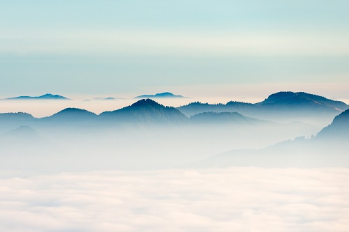 The Coast Range Mountains divided the homelands of Coastal Indian groups from the Native peoples of the Western Interior. (Oregon Scenic Images collection)
 East and south of the coastal mountain ranges and in the valleys of the Willamette, Umpqua and Rogue rivers, the Native peoples of the Western Interior created lives that in many ways merged those of Coastal, Great Basin and Plateau Indians. Salmon and other fish contributed to the diets of these peoples, including the Kalapuya and Upper Umpqua, but expert hunting of amu’ki’ (deer) and antká’ (elk) were also common sources of protein. Their seasonal rounds did not range as far as those of the Plateau and Great Basin peoples, but their knowledge of different environments and opportunities was just as sophisticated, particularly in their harvesting and processing of edible plants, including dinibgwí’ ampgwi’ (hazelnuts), many types of berries, and, most importantly, dinidi “p (camas). Western Interior Indians developed the knowledge to harvest the camas bulb and roast it in preparation for both storage as well as, in large amounts, trading; they, like other Native peoples, also regularly burned prairies and savannahs, which assisted in plant propagation. Fire also facilitated berry and acorn collection by creating open areas, assisted in the harvest of tarweed seeds in the fall, and developed fringe environments on the edges of prairies and forests that attracted game for hunting. Those foods, carefully preserved, carried the peoples of the valleys through the cooler and wetter months of winter, when they returned to permanent villages, often close to lakes.
The original Oregonians participated in worlds of cycle and tradition, but also of change. Major disruptions, such as the eruption of Mount Mazama or earthquakes in the Pacific that produced enormous tidal waves, led to significant changes for Native peoples, including displacement. Less dramatic changes, such as the gradual cooling of the climate 4,000 years ago, also led to migration and further adaptation. Seasonal rounds took Native peoples to familiar grounds, but their travels changed for a variety of reasons: a particularly dry or wet season that delayed or accelerated root and edible plant production, for example, or the development and improvement of new tools and technologies such as weirs for harvesting fish. Native societies expanded, contracted and evolved in response to new goods, ideas and people incorporated through trade networks. These networks also brought horses, which arrived on the Columbia Plateau in the 1700s, leading to more mobility and significant social change among the Cayuse, Nimiipuu and Umatilla. These animals, reintroduced to North America by the Spanish, were one of the most significant manifestations of a new connection to Europe, from which trade goods, diseases and eventually people soon would enter the worlds of the original people of Oregon.
Next: Oregon and Imperial Ambition >