Written by Jason D. McClaughry, Oregon Department of Geology and Mineral Industries, 1995 3rd Street, Suite 130, Baker City, OR 97814
Introduction
Geology is a historical science that describes the evolution of the three-dimensional Earth with the addition of a fourth dimension: time. The approximately 4.6-billion-year natural history of Earth is told by geologists, who unravel a complex past through careful observation and study of clues written into the rock record. These clues urge geologists to ask questions about “how?”, “why?”, and “when?”. The answers and hypotheses they develop from such questions help bring long-vanished landscapes and environments back into view. They add context to the nature of both the Earth’s slow incremental changes as well as of its major catastrophes.
Thomas Condon, a 19th century minister and Oregon’s first State Geologist, held that “In prying apart the stone layers of the rocks the scientist is in reality opening the leaves of the past history of our world, and that in these buried leaves of sand stone and mud deposits of seas and lakes of former ages, he is uncovering not only the real shells and bones of the life of the period, but even the ripple marks of the water that once covered them”. But what is the critical importance of seeking answers about our geologic past? Like Thomas Condon, it is now widely understood that the dynamic nature of the geologic past and present is the key to our future. These keys unlock more accurate predictions of what lies ahead so we might become more resilient to future geologic change.
Oregon is a land of natural geologic wonder, with a rock history verified back some 400 million years. The rocks tell a story of a region shaped by long-lived plate tectonic interactions between the western edge of the North American Plate and the plates that underlie the ancestral and modern Pacific Ocean. Dynamic processes of plate-to-plate collisions, interaction with a mantle plume, volcanic activity, earthquakes, faulting and folding, erosion, and sedimentation have all contributed to the formation of Oregon’s familiar landscapes. Landscapes in the Klamath Mountains, Coast Range, Willamette Valley, Columbia River Gorge, Cascade Range, Blue Mountains, High Lava Plains, Basin and Range, and Owyhee Uplands all provide an account of Oregon’s long geologic history. How did these landscapes come to be as we see them now?
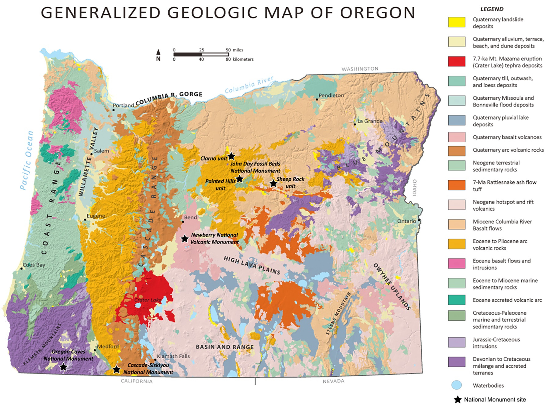 Generalized geologic map of Oregon showing the locations of the national monuments. (Source: DOGAMI) Open image in larger view
Next: Oregon Monuments >
About the Author
Jason McClaughry is a Registered Professional Geologist and is the Eastern Oregon Regional Geologist and Program Manager for the Geological Survey and Services Program at the Oregon Department of Geology and Minerals (DOGAMI). He holds an M.S. degree in Geology from Washington State University and a B.S. degree in Geology from the University of Puget Sound.