Remarkable Ecology and Diversity
Cascade-Siskiyou National Monument straddles the Oregon-California border near Ashland in Jackson County. This 114,000-acre national monument was established by Presidential proclamation in 2000 in recognition of the area’s remarkable ecology and to protect its diverse range of biological, geological, aquatic, archeological, and historic resources. The monument area was expanded to 170,686 acres in 2017 and includes the Soda Mountain Wilderness. It is managed by the Bureau of Land Management.
Cascade-Siskiyou National Monument is in an area where the Great Basin meets two geologically distinct mountain ranges: the Siskiyou and the Cascades. It is a place of complex geology, steep rock canyons, towering fir forests, sunlit oak groves, and wildflower-strewn meadows. Visitors explore the monument via a network of trails, including 19 miles of the Pacific Crest National Scenic Trail. Hyatt Lake Recreation Area, in the northeast part of the monument, is a popular site for boating and camping.
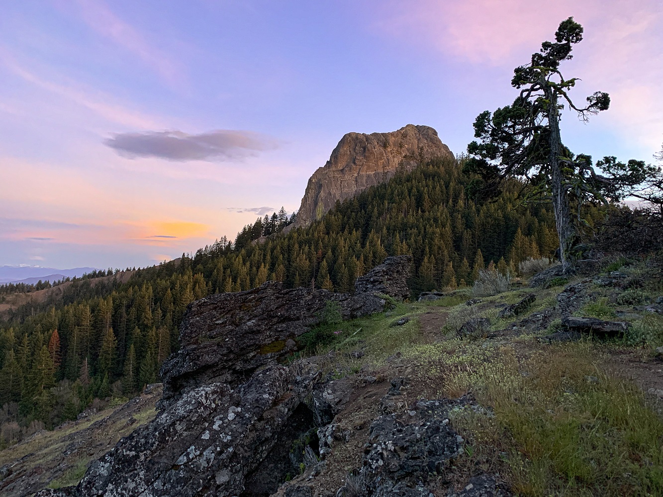 The beautiful Pilot Rock is one of the most recognizable features at Cascade-Siskiyou National Monument. (Oregon State Archives photo)
A Volcanic Legacy
Most of the Cascade-Siskiyou National Monument is part of the Cascade Range and thus is volcanic in origin; however, much older terrane rocks do crop out along the western edge in the Siskiyou Mountains. Geologic distinctions in the dominantly volcanic rocks of the Cascades and older terrane rocks underlying the Siskiyou range have produced a highly varied landscape marked by differences in topography, climate, and biology. The early geologic history in this part of the Siskiyou Mountains is related to formation of the Applegate terrane. Rocks of the Applegate terrane record a history of ocean sediments filling a basin near a chain of volcanoes between 212 and 192 million years ago. After merging with other Klamath Mountains terranes and docking with southwestern Oregon, magma invaded the Applegate terrane, cooled, and formed the Ashland pluton 160 million years ago. This was part of a larger magmatic event that also formed the Grayback pluton in Oregon Caves National Monument around the same time.
Starting about 100 million years ago, muddy, sandy, and gravelly sediments were being deposited along Oregon’s ancient Pacific coastline. This coastline was different than the north to south one we know today. One hundred million years ago the ocean was further inland with a coastline stretching northeast across the state from Medford to Pendleton. Rock remnants of this coastline are now preserved in sedimentary rocks of the Hornbrook Formation in the Klamath Mountains and in similar formations cropping out at the west end of the Blue Mountains. These rocks were deposited in what geologists refer to as a forearc basin. The basin was located between an oceanward subduction zone on the west and a large chain of volcanoes that existed in central Idaho during this time.
Rocks of the Payne Cliffs Formation were deposited across the Hornbrook Formation by a large river system draining a broad, flat plain between 50 and 40 million years ago. The Early Western and High Cascades Mountains were built by volcanic activity across older river deposits of the Payne Cliffs. Since 34 million years ago, persistent volcanic activity in this part of the Cascade Range has built and erased many individual volcanoes, and deposited a wide array of vent rocks, lava flows, mudflows, and falls and flows of ash. Pilot Rock, a prominent 25.6-million-year-old volcanic intrusion, is part of this volcanic sequence in the monument. Uplift of the Klamath Mountains, starting about 20 million years ago resulted in eastward tilting of all rocks in the monument.
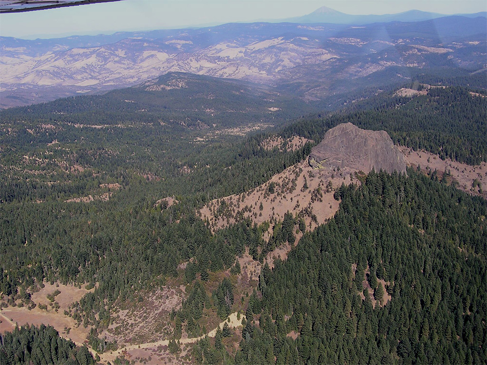 Aerial view of Pilot Rock and part of the Cascade-Siskiyou National Monument. Mt. McLoughlin is in the far distance. View is looking northeast across the southern part of the Bear Creek Valley. Photo Credit Jad D’Allura, 2020.
Oregon’s Geologic Future
Oregon’s national monuments are natural laboratories of high-societal value, protecting and preserving evidence of our geologic past. They provide both for scientific insight and opportunities for public education into long- and short-term climate change, evolution of plant and animal life, the relationships between rocks, landscapes, soils, and ecology, and geologic hazards. Geologists play an integral role in the study of Oregon’s national monuments, discovering the details of our past and providing all of us a toolbox to be resilient to future geologic change.
Next:
Oregon Monuments Home Page >