View of Paulina Lake from the top of the Big Obsidian Flow in the Newberry National Volcanic Monument. (Oregon State Archives scenic photo)
View of Paulina Lake from the top of the Big Obsidian Flow in the Newberry National Volcanic Monument. (Oregon State Archives scenic photo)
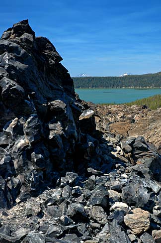
Newberry National Volcanic Monument is a place of exceptionally ancient significance. Over 10,000 years ago, this was the site of village settlements and camps, as well as important hunting grounds. Across time, the spring waters that bubbled to the surface here, and the lakes of Newberry Crater—Paulina and East Lake—sustained residents and visitors alike. Yet, this landscape stood apart for other reasons as this was among the Northwest’s most important places to quarry obsidian, which occasionally erupted from the ground, flowed downslope, and hardened into ridges of glassy black rock stretching across the volcanic landscape. Reflecting this remarkable antiquity of human use, tribal oral tradition speaks of the place as a center of settlement and obsidian gathering since the beginning of remembered time. Archaeologists also attest to the depth of human connections to this place, uncovering settlements and quarries buried below deep ash from Mount Mazama, which erupted and collapsed some 7,700 years ago to form Crater Lake.
Obsidian and Indigenous Culture
Some of Newberry’s obsidian flows long predated human settlement while others emerged anew during eruptions witnessed by tribal ancestors. In the oral traditions handed down across generations, these obsidian deposits are described as a gift from the Creator, delivered for the benefit of humanity. From Newberry obsidian, traditional craftspeople fashioned arrowheads, spears, scrapers, knives, and tools for many other purposes. Each flow had distinct properties. In one place, people might find simple black obsidian of remarkable strength, useful for constructing arrowheads, spearheads, and other tools for hunting game. Said to "crave blood," the ancestors treated this kind of rock with caution and respect. In other places, less durable obsidian, marked with vivid colors or patterns, could be fashioned into items for ceremonial and ornamental use. Each flow was known and visited in turn, depending on the need. At one time, trails radiated out in every direction from these deposits like spokes of a wheel, marked by the debris from ancient traders and toolmakers who occasionally chipped away at the stone as they traveled. In turn, these trails intersected with major trade routes that ran north-south along the approximate route of today’s Highway 97, connecting the people of south and central Oregon with the major fishing stations and trade centers on the Columbia—at Celilo Falls and The Dalles—where this obsidian was in high demand.
Newberry and Indigenous Tribes Today
As settlers and the U.S. military entered central Oregon in the mid-19th century, the landscape took on additional layers of significance. The Paiute band led by Chief Paulina, for example, visited this spiritually-potent place and used it as a hideout while resisting relocation to the Klamath Reservation in the 1860s. By the time central Oregon’s "Indian wars" were over a decade later, the people who lived near Newberry had been relocated to the Klamath Reservation, the nearby Warm Springs Reservation and other tribal reservations and communities such as Burns Paiute east of the Cascades. The Monument remains significant to these tribes today—and to many others across the region, reflecting the celebrated significance of Newberry Crater obsidian. Certain tribes still visit, occasionally gathering obsidian for use by tribal youth in summertime "culture camps" that teach obsidian toolmaking and other traditional crafts of enduring cultural significance.