Mountains, Major
Blue Mountains: This northeastern Oregon mountain chain is part of the Columbia Plateau, which extends into southeastern Washington. Lava flows cover much of the surface, and the upper, wooded slopes have been used for lumbering. Today, recreation and livestock grazing are the principal economic uses. The highest elevation is Rock Creek Butte (9,105'), located on the Elkhorn Ridge a few miles west of Baker City.
Cascade Range:
This lofty mountain range extends the entire north–south length of Oregon east of the Willamette Valley. It lies about 100 to 150 miles inland from the coastline and forms an important climatic divide, with the western slopes receiving abundant precipitation but the eastern slopes very little. The western slopes are heavily wooded, with the eastern section mainly covered by grass and scrub plants. Many lakes and several large rivers are in the mountains, the latter harnessed for hydroelectric power. The range is used frequently for outdoor recreation. The highest elevations are Mt. Hood (11,237'), located in Clackamas and Hood River Counties, and Mt. Jefferson (10,495'), located in Jefferson, Linn and Marion Counties.
Coast Range: The Coast Range runs the length of the state along the western coastline, from the Columbia River in the north to the Rogue River in the south. These mountains contain dense soft-wood forests, which historically made lumbering an important economic activity. Their eastern slopes mark the western edge of the Willamette Valley. The highest elevations are Mt. Bolivar (4,319') in Coos and Curry Counties; and Mary’s Peak (4,097') in Benton County.
Klamath Mountains:
The Klamath Mountains in southwestern Oregon are sometimes included as part of the Coast Range. These mountains include numerous national forest and wildlife preserves and contain scenic portions of the Klamath River. The highest elevation is Mt. Ashland (7,532') in Jackson County.
Steens Mountain: This is a massive, 30-mile-long mountain in the Alvord Valley, featuring valleys and U-shaped gorges that were cut by glaciers one million years ago. Located in Harney County in southeastern Oregon, it is 9,773' in elevation.
Mushroom, State
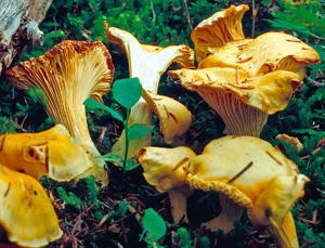 Pacific Golden Chanterelle mushrooms.
 The 1999 Legislature recognized the Pacific Golden Chanterelle (
Cantharellus formosus) as the state mushroom. This mushroom is a wild, edible fungus of high culinary value that is unique to the Pacific Northwest. More than 500,000 pounds of Pacific Golden Chanterelles are harvested annually, representing a large portion of the commercial mushroom business.
Name of Oregon
The first written record of the name “Oregon” comes from a 1765 proposal for a journey written by Major Robert Rogers, an English army officer. It reads, “The rout . . . is from the Great Lakes towards the Head of the Mississippi, and from thence to the River called by the Indians Ouragon.” His proposal rejected, Rogers reapplied in 1772, using the spelling “Ourigan.” The first printed use of the current spelling appeared in Captain Jonathan Carver’s 1778 book,
Travels Through the Interior Parts of North America 1766, 1767 and 1768. He listed the four great rivers of the continent, including “the River Oregon, or the River of the West, that falls into the Pacific Ocean at the Straits of Annian.”
While no definitive pronunciation of “Oregon” is given in
Oregon Geographic Names, the most common pronunciation by long-time Oregonians is “OR-ih-gun.”
National Cemeteries
Willamette, Portland (1950);
Eagle Point (1973);
Roseburg (1973);
Fort Stevens (2020)
National Fish Hatcheries
Eagle Creek, Estacada (1956);
Warm Springs (1966)
National Forests
Deschutes (1908); Fremont-Winema (combined 2002: Fremont est. 1908, Winema 1961); Malheur (1908); Mt. Hood (1908); Ochoco (1911); Rogue River-Siskiyou (combined 2004; Rogue River est. 1908, Siskiyou 1907); Siuslaw (1908); Umatilla (1908); Umpqua (1908); Wallowa-Whitman (combined 1954: both est. 1908); Willamette (1933)
National Grassland
Crooked River National Grassland, near Madras (1960)
National Historic Landmarks
Bonneville Dam Historic District, Multnomah County and Skamania County, Washington (1987)
Crater Lake Superintendent’s Residence, Klamath County (1987)
Columbia River Highway, Multnomah, Hood River and Wasco Counties (2000)
Deady and Villard Halls, University of Oregon, Lane County (1977)
Fort Astoria Site, Clatsop County (1961)
Fort Rock Cave, Lake County (1961)
Kam Wah Chung Company Building, Grant County (2005)
Jacksonville Historic District, Jackson County (1966)
Lightship WAL-604 “Columbia,” Clatsop County (1989)
Lower Klamath Wildlife Refuge, Klamath County and Siskiyou County, California (1965)
Oregon Caves Chateau, Josephine County (1987)
Pioneer Courthouse, Multnomah County (1977)
Skidmore/Old Town Historic District, Multnomah County (1977—Updated documentation approved 2008)
Sunken Village Archeological Site, Multnomah County (1989)
Timberline Lodge, Clackamas County (1977)
Wallowa Lake Site, Wallowa County (1989)
Watzek Aubrey House, Multnomah County (2011)
Cascade-Siskiyou, near Ashland (2000);
John Day Fossil Beds, located in three units near Kimberly, Mitchell and Fossil (1975);
Newberry National Volcanic Monument, near Bend (1990);
Oregon Caves, near Cave Junction (1909)
National Parks
Crater Lake (1902);
Lewis and Clark National Historical Park in Oregon/Washington (1958);
Nez Perce National Historical Park in Oregon/Idaho/Montana/Washington (1965)
National Recreation Areas
Hells Canyon National Recreation Area in Oregon/Idaho (1975);
Oregon Dunes National Recreation Area (1972)
National Scenic Areas
Columbia River Gorge National Scenic Area (1986); Cascade Head Scenic Research Area (1974)
National Wildlife Refuges
Ankeny, near Jefferson (1965);
Bandon Marsh, near Bandon (1983);
Baskett Slough, near Dallas (1965);
Bear Valley, near Klamath Falls (1978);
Cape Meares, near Tillamook (1938);
Cold Springs, near Hermiston (1909);
Hart Mountain National Antelope Refuge, near Lakeview (1936);
Klamath Marsh, near Klamath Falls (1958);
Lewis and Clark (1972);
Malheur, near Burns (1908);
McKay Creek, near Pendleton (1927);
Nestucca Bay, near Pacific City (1991);
Oregon Islands, off southern Oregon coast (1935); Siletz Bay, near Lincoln City (1991);
Three Arch Rocks, off coast near Oceanside (1907);
Tualatin River, near Sherwood (1992);
Umatilla, near Irigon (1969);
Upper Klamath, near Klamath Falls (1928);
Wapato Lake, near Gaston (2013);
William L. Finley, near Corvallis (1964)