Maximum Grades
Sam Lancaster used the figure shown above to illustrate how more gradual slopes could lower the cost of transporting freight. At the time, wagon roads in the Columbia River Gorge typically used grades of 10 to 20 percent in order to negotiate the rugged terrain. Based on his experiments at Maryhill, Lancaster found that 5 percent grades created safer and more pleasant inclines. (Image: Library of Congress, Prints & Photographs Division, HAER ORE, 26-TROUT.V1- (sheet 9 of 27))
Minimum Radius and Curve Widening
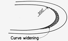
In order to eliminate dangerous hairpin turns often found on mountain roads of the period, designers followed standards that included a minimum turning radius of 200 feet. They allowed some exceptions, such as those related to loops described below, but never created a turning radius of less than 100 feet. The roadway was also gradually widened from 2 to 6 feet on the inside area of curves to increase safety for cars. (Image: Library of Congress, Prints & Photographs Division, HAER ORE, 26-TROUT.V1- (sheet 9 of 27))
Crowning and Superelevation
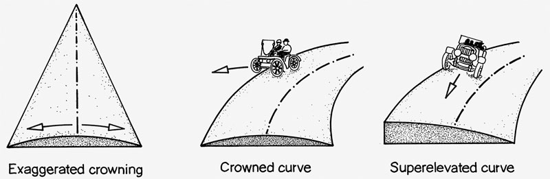
Highway designers have long relied on crowning, in which the road is sloped down from the middle to the shoulder, to drain water away from the driving surface. This avoids water collecting in pools that could cause tires to dangerously hydroplane or lose traction. However, these slopes, combined with the natural properties of curves, tend to pull vehicles off the road. Instead, designers developed curve banking, or sloping the road in the direction of the inside of the curve, to take advantage of the centrifugal forces associated with curves. This "superelevation" allows drivers on today’s modern roadways to maintain speeds in curves that would otherwise require them to slow down. In contrast, the designers of the Historic Columbia River Highway decided that “any curve necessitating a super-elevation was dangerous and speed should be slackened and in any case should be enough to prevent side-lash to passengers in a machine at 25 miles an hour; but that the general rule should be nearer a speed of 15 miles per hour.” The historic highway does use superelevation, but it is mostly to enhance water drainage in curves. (Image: Library of Congress, Prints & Photographs Division, HAER ORE, 26-TROUT.V1- (sheet 9 of 27))
Continuous Curves
The Historic Columbia River Highway is known for its continuous curves, which offer great scenic views and enhance the aesthetic experience. But these reversing curves serve more practical purposes as well. The meandering route was longer in distance than straight stretches and this allowed designers to use shallower grades between the same points. Less cutting and filling of the terrain, such as is common along modern highways and freeways, was needed because the continuous curves could trace the natural terrain better than straight roads. Finally, according to the Historic American Engineering Record, connecting continuous curves also “eliminated potential flat spots between, where crowning might remain level until the next curve. Water collecting there could be potentially hazardous to drivers and also lead to pavement breakdown."
Equipment
Contractors excavated the roadbed of the Historic Columbia River Highway with a combination of men, horses and heavy machinery. In one case, 30 men, aided by a steam shovel with a 20-cubic-yard dipper, four large air drills, two 15-ton dinkeys (small locomotives) and 30 4-yard ore cars moved 1,600 cubic yards of overburden and rock during an 8-hour day.
Loops
The steep and rugged terrain of the land available for building the highway in some locations along the route created challenges in maintaining the standard minimum radius and maximum grade. For example, the road at Crown Point wound around a bluff to Latourell Falls, creating the need to drop 600 vertical feet within a 40-acre tract. Designers solved the problem by looping the road back and forth down the hill, thus developing distance between the starting and ending points and keeping the maximum grade at 5 percent. They did compromise by cutting the standard 200-foot curve radius to 100 feet, but compensated for this by reducing the grade by one percent for every 50-foot reduction in curve radius.
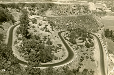
The Rowena Loops just east of Rowena Crest. (Oregon State Archives, Private Donation Postcards)
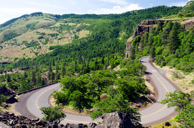
A view of the Rowena Loops in 2012.
(Oregon State Archives, Scenic Image No. D7K-0106)
Credit
Most of the information on this page was adapted from the Historic American Engineering Record, National Park Service, Helen Selph & Elaine G. Pierce, 1995. (Library of Congress, Prints & Photographs Division, HAER ORE, 26-TROUT.V1- (sheet 9 of 27))